Explore our solutions
Machine learning solutions for subsurface workflows
Enhance your subsurface characterization workflows with our embedded Machine learning solutions


Overview
Faster and more accurate subsurface characterization
Interpretation and modeling are crucial to exploration and production activities, but extraction of tangible value from datasets still poses a major operational bottleneck for geology and geophysics (G&G) workflows.
Manual and intensely repetitive procedures, with a vast throughput of data, contribute to a time-consuming process that often yields inconsistent results.
Our ML solutions and advanced digital technologies are revolutionizing the reservoir characterization landscape, by enhancing fault and horizon identification, interpretation, and improving reservoir modeling.
Machine learning in the hands of Petrel users
Our machine learning solutions are integrated into Petrel™ subsurface software, providing users with direct access to ML capabilities. These solutions are accessible with the appropriate subscription and license, both in the cloud and on premises.
Enhanced interpretation workflows
Workflow specific extraction, analysis, and filtering tools have been created to enrich both ML fault and horizon interpretation workflows. Improve cross-disciplinary integration by outputting results in a unified software package.
ML multi-horizon prediction in Petrel subsurface software
Machine learning (ML) multi-horizon prediction is a new solution for Petrel software in 2024, that uses the latest technology to predict multiple non-continuous horizons simultaneously. Easy-to-use filtering and post processing tools integrated in Pe
-
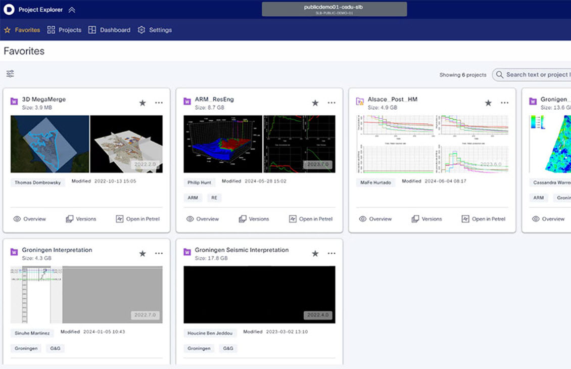
Petrel Project Explorer
Available as part of Lumi™ data and AI platform essentialsThe new, more powerful way to work with Petrel software projects in the Delfi™ digital platform.
-
Seismic streaming
Available as part of Lumi™ data and AI platform essentialsHigh-performance seismic data streaming directly into Petrel software on the Delfi platform.
-
ML fault interpretation
Drastically reduce the faults interpretation cycle time with machine learning.
-
ML horizon interpretation
Predict geologically consistent horizons using cutting edge ML technology.
-
ML multi horizon interpretation
Predict multiple non-continuous horizons simultaneously.
-
ML property modeling
Rapidly deliver reservoir models with increased efficiency and coincidence.
-
ML raster digitization interpretation
Unlock raster data with machine learning.


Machine Learning video resources
Deep Dive
Petrel project explorer
Project explorer is the new, more powerful, way to work with Petrel projects in the Delfi™ digital platform.
Traditional project management comprises time-consuming “save as” workflows, where end users spend a considerable amount of time on data management tasks. Data and projects are routinely duplicated, without appropriate audit trails and project versioning. This creates ever-increasing amounts of required storage and associated costs. In addition, data remains siloed in the application and its sharing can be cumbersome.
Project explorer automatically saves incremental, immutable versions of Petrel™ subsurface software projects. As a result, project “save as” times are no longer required with full versioning control enabled. If you need to roll back to a previous saved version of the project, whether it was an hour, a month, or even a year ago, you can, quickly and simply. This is also true for specific data from previous versions. Increase the speed at which you work with peace of mind, knowing you can always revert if needed.
Petrel Project Explorer
Brief video on Petrel 2020's project explorer

An overview of the favourite projects tab in Project explorer
Project explorer also promises sizeable performance improvements. Saving a new version of a project in Project explorer is 30-times faster than making a copy on traditional file system. Options such as smart retrieval of simulation cases have been implemented to improve project loading time by 75–95% for large Petrel software projects with many simulation cases.
The interface of Project explorer is intuitive and accessible from within Petrel software or via a web browser. It shows all project versions from all users, and allows the viewing of data associated with each project. This includes images of the windows that are created in the project, project attributes, custom tags, (coordinate reference systems, time zone etc), and all data stored in the project. It relieves users from Petrel software project management tasks, and improves the focus on domain workflows for value creation.
Project explorer also enables the effortless exchange of data from Petrel software into the OSDU® Data Platform, to provide wider access to data and projects, increasing team collaboration and driving insights.
Petrel explorer is available on the Delfi™ digital platform. Contact us to find out more!
Seismic streaming in Petrel software on the Delfi platform

Seismic explorer interface and seismic streaming. | Dataset developed by the Nederlandse Aardolie Maatschappij and the Dutch research infrastructure of solid earth sciences (NAM 2020).
High performance seismic data streaming directly into Petrel software on the Delfi platform
Seismic volumes have been progressively increasing in size and complexity over recent years, encompassing decades of material and requiring petabytes of storage. These volumes are typically stored externally to software applications in shared file systems. The increase in seismic volume sizes, coupled with the costs of storing these volumes, and the performance requirements in domain applications, still remain a challenge to this day.
Seismic streaming in the Delfi platform provides high-performance seismic data (OpenZGY) streaming directly into Petrel software. Now you can manipulate and visualize seismic volumes greater than 1TB in size for performant seismic workflows on a truly regional scale, removing performance bottlenecks for seismic reconnaissance workflows and taking advantage of advances in streaming technology.
Utilizing the intuitive seismic explorer interface in Petrel software, it is now easier than ever to share and consume seismic volumes across teams, increasing collaboration and reducing the requirement for duplication and user data management.
The integration of the seismic OpenZGY file format with the OSDU platform delivers an optimized cloud storage experience which not only provides end users with a significant boost in seismic performance, but also cost-efficient storage compared to current storage solutions. This will improve rapid reconnaissance and interpretation of large seismic cubes in exploration or development scenarios.
Seismic streaming is available on the Delfi platform. Contact us to find out more.

Illustration of ZFP's ability to vary the compression ratio to any desired setting. | Image courtesy of LLNL(Lawrence Livermore National Laboratory)
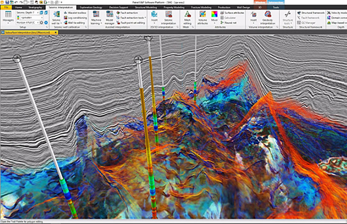
ML fault interpretation
ML fault interpretation
Drastically reduce the seismic interpretation cycle time with ML
With our ML-assisted seismic interpretation workflow, machine learning is now at the fingertips of seismic interpreters. Using pre-trained and user-trained prediction approaches, faults can be efficiently identified and analyzed. Pre-trained models provide fault prediction cubes for analyzing main fault trends, while user-trained models allow geoscientists to focus on specific fault characteristics. By adjusting fault labels and retraining, a wide range of complex geological scenarios can be addressed!
Contact us to find out more!
ML horizon interpretation
Accelerate subsurface characterization with embedded machine learning
Geoscientist-driven ML for interactive interpretation of geological horizons from seismic, allows users to reduce horizon interpretation cycle time. No daunting parametrization is needed from the user, as is typically required using standard auto-tracking techniques, and the user primarily focuses on interpretation of horizon labels and on the geology rather than the parametrization.
Horizons are predicted and extracted using an ML approach which leverages both on 1D neural nets and radial basis function models. The ML horizon approach predicts reflector events based on minimal amounts of training data, reducing the time taken to interpret.
Contact us to find out more!
ML horizon interpretation
ML multi horizon interpretation
Predict geologically consistent horizons using cutting edge ML technology
ML multi-horizon prediction is a geoscientist-driven machine learning for rapid and simultaneous prediction of multiple horizons, including non-continuous horizons, e.g. unconformities, thin layers, onlapping horizons.
Geologically consistent horizons enable users to create more accurate subsurface frameworks in a shorter timeframe. Reduce interpretation and structural modelling cycle time, whilst also predicting non-continuous horizons.
Contact us to find out more!

Data attribution: Data courtesy of Geoscience Australia
ML quantitative interpretation
ML quantitative Interpretation
Machine learning assisted quantitative interpretation is available in Petrel
Machine learning assisted quantitative interpretation is now available in Petrel software and can be used for quick-look analysis to improve screening workflows. Machine learning and amplitude versus offset (AVO) based training and prediction of elastic and petrophysical properties (porosity, sand volume, etc) from seismic angle stacks.
Using the FastTree method, this process builds each regression tree in a step wise fashion. Petrel 2024.2 improves this workflow with automated machine learning (AutoML), which systematizes the selection and parametrization of machine learning models. AutoML iterates over different data transformations, machine learning algorithms, and hyperparameters, to select and apply the best model increasing the efficiency for screening workflows!
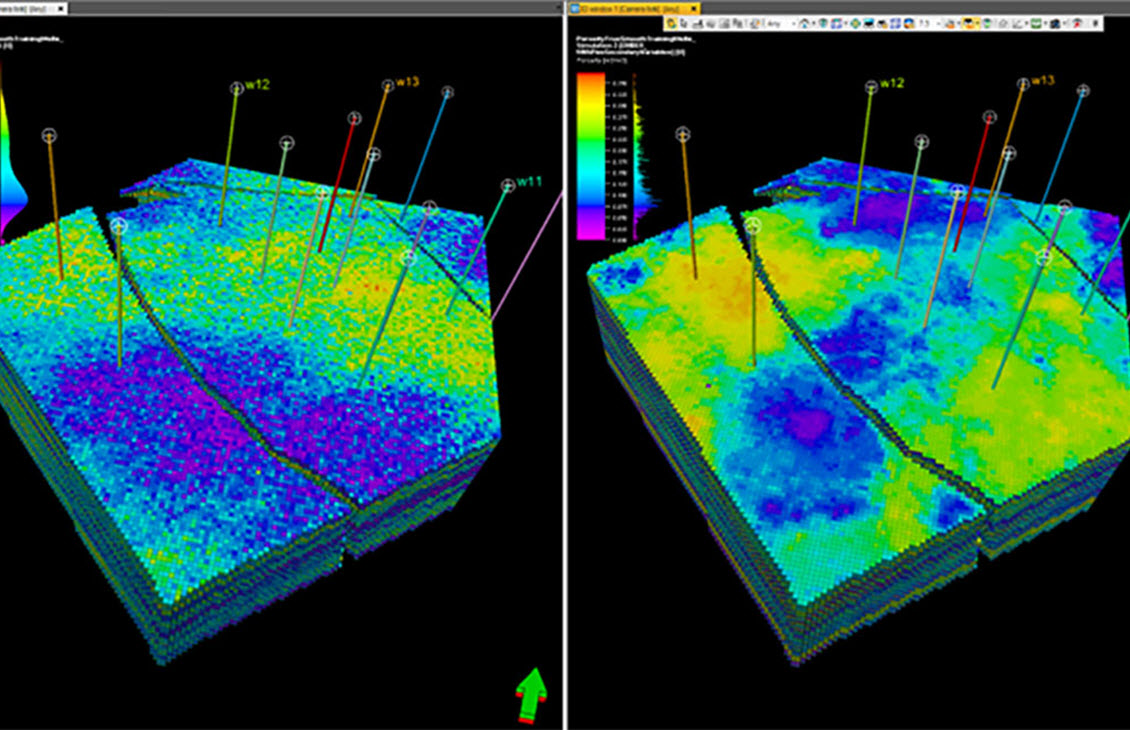
ML property modeling
Rapidly deliver reservoir models with increased efficiency and confidence
Machine learning for property modeling utilizes the Embedded Model Estimator (EMBER) algorithm, which leverages machine learning combined with classic geostatistical estimation and simulation techniques to produce robust stochastic property predictions.

Left: Traditional sequential gaussian simulation (SGS), Right: EMBER, both with relative acoustic impedance (RAI) as a secondary variable at the top of the reservoir.

Left, SGS with RAI as a secondary variable; Right: EMBER using multiple secondary variable including RAI, both at the middle layer of the reservoir
Empowered by ML, with the EMBER algorithm users can deliver reservoir characterization studies with increased efficiency and confidence. This shifts the focus of user effort to where it matters most, exploring and understanding the subsurface geology along with associated uncertainties.
Benefits of Machine Learning for Property Modeling:
- Reduce workflow steps by 75% compared to traditional geostatistical approaches, eliminating the need for extensive manual data analysis by zone and region.
- Easily generate more scenarios and explore their corresponding unbiased predictions of “sweet spots” and uncertainty.
- Combine multiple secondary variables seamlessly using advanced ML models that quickly train on your reservoir data within the context of your study.
- Utilize blind well testing and QC reports to support model and property analysis, enabling you to deliver results with confidence.
- Leverage intervention workflows to condition models with additional information, such as conceptual geological inputs, tuning the model to incorporate field knowledge.
- Robust simulation approach, better constrained to data.
Enabling modelers to make higher confidence reservoir informed decisions.
ML multi-horizon prediction in Petrel subsurface software
Machine learning (ML) multi-horizon prediction is a new solution for Petrel software in 2024, that uses the latest technology to predict multiple non-continuous horizons simultaneously. Easy-to-use filtering and post processing tools integrated in Pe
ML multi-horizon prediction in Petrel subsurface software
Machine learning (ML) multi-horizon prediction in Petrel software uses the latest technology to predict multiple non-continuous horizons simultaneously.
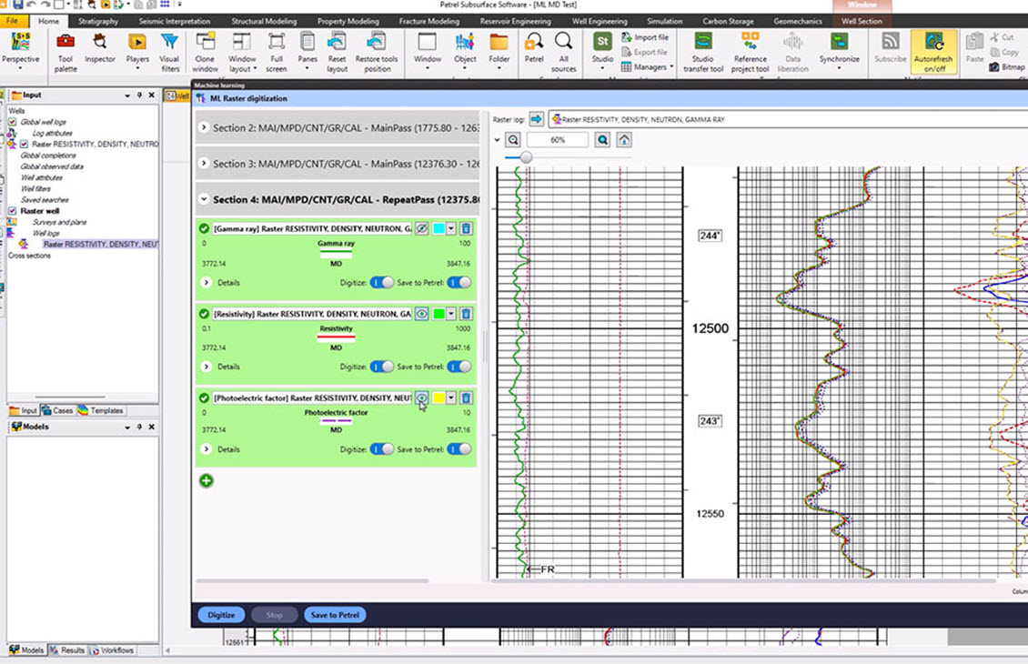
ML raster digitization interpretation

Unlock raster data with ML today
The ML Raster digitization tool simplifies the digitization of raster log curves, unlocking valuable data for geological interpretation and reservoir modeling. Effortlessly digitize single or multiple curves for your area of interest on demand. The results are seamlessly integrated into Petrel, facilitating easy sharing between colleagues. Unlock deeper insights from your reservoir today!
Contact us to find out more!
Success stories
-
AI Accelerating Exploration and Reservoir Characterization
Structural interpretation time reduced by 80%.Structural interpretation time reduced by 80%. What will you change?
-
Dragon Oil using AI to Enhance Planning and Performance in a Mature Offshore Field
SLB and Dragon Oil to optimize modeling and field-development plan (FDP) workflows in a mature offshore fieldSLB and Dragon Oil to optimize modeling and field-development plan (FDP) workflows in a mature offshore field.
-
Pertamina Hulu Mahakam utilizes machine learning to reduce property modeling time
Pertamina Hulu Mahakam (PHM) utilizes machine learning to reduce time and improve the accuracy of 3D property modeling in its upstream operations.Pertamina Hulu Mahakam (PHM) utilizes machine learning to reduce time and improve the accuracy of 3D property modeling in its upstream operations.


See how ML can rapidly enhance value realization today
With a world-class selection of machine learning (ML) solutions on offer to tackle the most complex of subsurface characterization challenges, our experts are always on hand to assist in applying the latest technology.
Contact usRelated Products
-
Petrel AI and ML on-prem
Machine learning for everyoneMachine learning solutions from the Delfi platform
-
AI in Delfi
Artificial intelligence for the energy industryArtificial intelligence for the energy industry.
-
Petrel software
Enable discipline experts to work together and make the best possible decisions from exploration to productionEnable discipline experts to work together and make the best possible decisions from exploration to production.
-
Lumi Data and AI Platform
Maximize, elevate, and scale data-driven decision making, with AIDrive digital and people transformations using full AI life cycle capabilities.
-
Techlog software
Integration of all wellbore-centric data types into multidiscipline workflowsIntegration of all wellbore-centric data types into multidiscipline workflows.
-
Agile Reservoir Modeling
Transforming SubsurfaceTransforming Subsurface.
-
Reservoir Engineering Solutions
Evaluate reservoir performance through simulation to maximize recoveryEvaluate reservoir performance through simulation to maximize recovery.
-
Planning
Accelerate decision making and improve value at every stage of developmentDon’t just plan your asset. Future-proof it!


Helpful links
About SLB